

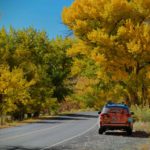
I haven’t been on all of Utah backroads, not even close, but I have to believe that the Burr Trail must be at the top or near the top of the list as the most scenic. #viewswitharoad
The Burr Trail passes through three iconic parks starting at Boulder to the north located on Highway 12 to Bullfrog Marina and Ticaboo to the south. The route offers backcountry access to trails and canyons through the painted rock country of Glen Canyon National Recreation Area, Waterpocket Fold and Badlands of Capitol Reef National Park, and Slickrock of the Grand Staircase-Escalante National Monument. The distance is 73-75 miles from Boulder to Bullfrog and Ticaboo respectively. The first 30 miles are paved leading to the Capitol Reef border. From there the road turns to graded dirt and can be “washboarded” in sections.
The upper section (paved section) includes Long Canyon and its tributary slot canyon called “Singing Canyon”, Deer Creek campground, and many amazing views. Once you exit Long Canyon there is an amazing panoramic view of the Waterpocket Fold and Circle Cliffs with the Henry Mountains looming in the background. Once you reach the Capitol Reef border the pavement ends and graded dirt begins. A short distance down the road from the border the Peek-A-Boo Arch at Upper Muley Twisted Canyon comes in to view. The first half mile of the side road to this area is passable for passenger cars, then the road enters Upper Muley Twist Canyon and is recommended only for 4WD vehicles.
One of the highlights of the trip is the Burr Trail Switchbacks. A shorter version of the Moki Dugway in San Juan County (SR 261) with steeper slopes and grade. The view from the top is amazing, worth a stop to get the photo. A short distance from the bottom of the Switchbacks is a junction. This is where the road from Hwy 24 east of Capitol Reef runs parallel to the Waterpocket Fold, passes through the small town of Notom and connects with the Burr Trail. This is a half-way point. From here Bullfrog is 33 miles to the south and 34 miles to the north to Hwy 24. From here the road enters the Badlands.
The Badlands are made up primarily of Mancos Shale and Morrison formations. You see these formations on Hwy 24 from Hanksville to Capitol Reef. Factory Butte and the Cainville Mesa are good examples of Mancos Shale. The road is this section, on the day I drove through, was “badly washboarded.” This will be a test of your suspension!
While negotiating my way through the washboard I came upon the junction with Starr Spring. This was the relief I was looking for! Turn right at the junction, this is where the road turns back to pavement. From here the road connects with Utah State Hwy. 276 in less than 20 miles.
Along this stretch, I stopped the car several times to take it all in. To the south, Upper Bullfrog Bay and Upper Halls Creek Bay can be seen. Shortly down the road is the Glen Canyon National Recreation Area boundary.
At approximately 5 miles from Bullfrog, there is a wash called Bullfrog Creek crossing. When Lake Powell is at full pool, water can extend up the wash as far as the road! After a rain, the wash can be wet and muddy. This could be the end of the trail if wet or full. Be sure to check on weather and lake conditions before leaving Boulder. The bigger concern is rain, the lake hasn’t been full pool in many moons.
How the road got its name
Named after John Atlantic Burr, who was born in 1846 aboard the SS Brooklyn somewhere in the Atlantic Ocean. He and his family lived in Salt Lake City, then later moved south and established the town of Burrville, Utah, in 1876. John Burr soon developed a trail to move cattle back and forth between winter and summer ranges and to market. This cattle trail through the rough, nearly impassable country around the Waterpocket Fold, Burr Canyon, and Muley Twist Canyon came to be known as the Burr Trail.
A note from the BLM: Although in dry weather the Burr Trail is easily accessible to passenger cars, wet weather may make the road impassable even for 4WD vehicles. Check with rangers or local officials for weather and road conditions. Recreational vehicles are not recommended.
Click on the button below to see a few photos from my trip down the Burr Trail.

Leave a Reply
Want to join the discussion?Feel free to contribute!